
 29, 30 NOV
 & 1 DEC 2026
 29, 30 NOV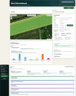
BSSi’s new Digital Mapping Platform transforms 15 parameters produced by Seed Sensing Technology into digital maps. Measurements are recorded in real time, extending in-cab and remote monitoring into spatial information that remains useful after planting. Operators can monitor planting performance and make adjustments during planting. Maps help growers identify where performance changed, direct field inspections and retain detailed records. The online dashboard combines planting maps with spacing statistics, crop and variety information, planting dates, field notes, satellite imagery options, and crop-stage and water-balance estimates. Growers can export this new seeding data for import into compatible farm-management platforms of their choice and use it alongside other field records. BSSi’s Ag Data Transparent certification covers Seed Sensing Technology and its online platform, supporting transparency around data ownership, use, sharing and protection.
Date of market introduction in Belgium (if still in development: expected date of launch)
2027
Briefly describe what is NEW. This explanation will be submitted to the expert group and will be decisive in the evaluation and selection of the most newsworthy entries. (max. textarea: 600 characters)
BSSi’s new Digital Mapping Platform transforms 15 parameters produced by Seed Sensing Technology into digital maps. Measurements are recorded in real time, extending the value of in-cab and remote monitoring into spatial information that remains useful after planting. The platform makes detailed seeding data available as maps that show where planting performance and conditions changed within a field. Growers can export this new seeding data for import into compatible farm-management platforms of their choice, bringing planting information into their existing digital workflows.
Added value for the user (in commercial terms, user-friendliness ...)
Operators can monitor planting performance and make adjustments during planting. The resulting maps help growers identify where performance changed, direct field inspections and retain detailed records for future decisions. The online dashboard brings planting maps together with spacing statistics, crop and variety information, planting dates, field notes, satellite imagery options, and crop-stage and water-balance estimates. Growers can export data to compatible farm-management platforms of their choice, allowing them to use planting information alongside other field records.
Added value for the further sustainability and professionalization of the potato sector.
Digital Mapping supports more systematic assessment of planting operations. Location-specific records help growers investigate inconsistencies, identify recurring issues and make better-informed decisions about equipment operation and input management. Exportable maps allow planting data to contribute to wider farm analysis and planning. BSSi’s Ag Data Transparent certification covers Seed Sensing Technology and its online platform, supporting transparency around data ownership, use, sharing and protection.